Wednesday, June 30, 2010

Pyrophotomania

RockledgeFire7
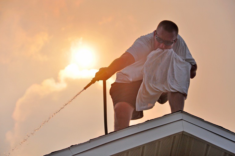
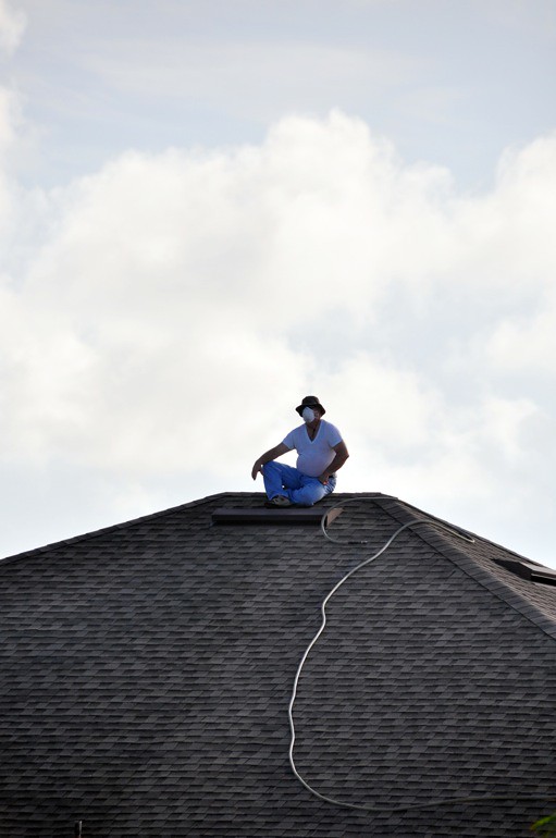
A resident hoses down the side of his house in the Chelsea Park subdivision, where burning embers from a wildfire in a nearby bird sanctuary threatened to ignite the home.


Last Tuesday, the day of my return from the first of three consecutive long weekends, I was called to work by an editor who said Rockledge was ablaze. Actually, it was a simple wildfire near a subdivision in the city, a subdivision where a friend of mine happens to live. So there was an added concern. When I got there, though, I discovered that the flames were far from her home but very near about 20 along a few streets in the community. I covered it for the newspaper through words and photographs, more of which can be viewed here.


RockledgeFire2
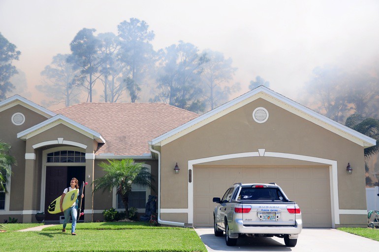
A teenager carries her most prized possessions - a surfboard and a skateboard - from her home after she was ordered to evacuate.

RockledgeFire1
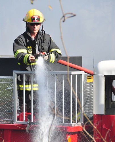
A county firefighter assessed the blaze from atop a special truck used in brush fires.

RockledgeFire8
The firefighters had considerably more hosepower.

RockledgeFire6
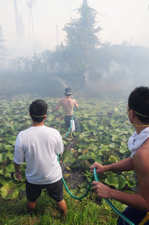
The fire and the homes were separated by a small canal, providing a natural barrier against the blaze. Still, residents used their garden hoses to douse small flames on the other side.

RockledgeFire3
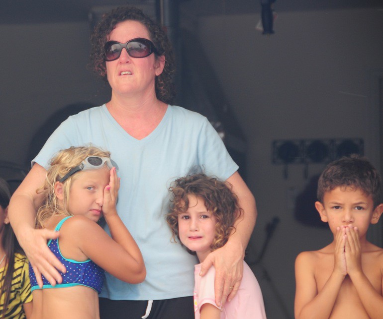
A woman, her daughter and some other local children gather closely while they look at flames shooting above their homes.

RockledgeFire5
A father comforts his frightened 8-year-old.

RockledgeFire4
All of these neighbors were quite concerned, but the firefighters stopped the flames.

RockledgeFire9
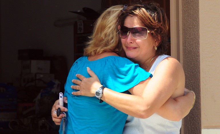
Finally, when the wildfire was contained, everyone could take a break.

Monday, June 21, 2010

SpaceX's Falcon 9 and the disaster that didn't happen

web_spacex_falcon9_0024_2846
For the maiden voyage of SpaceX's Falcon 9 rocket, I sat for four hours on a lens case, waiting for the thing to blast off. My makeshift chair was provided by James Murati, a contract photographer for United Launch Alliance, which could be considered a competitor for SpaceX in the commercial launch business. SpaceX is a leading candidate to provide cargo launch services to the International Space Station and possibly manned flights someday. This launch on June 4 was a demonstration - or test - flight for the rocket itself, and it had a high probability of failure. That's why James and I waited for four hours in the hot sun until the crew at SpaceX managed to shake off a technical glitch and finally push the button.

web_spacex_falcon9_0033_2847
I set up my tripod and camera on the sandy shore of the Banana River - as opposed to the bank - along a stretch of Port Canaveral, the closest public viewing site for liftoffs from Launch Complex 40 at Cape Canaveral Air Force Station. My low angle put the horizon - the launch pad - out of site. The optical illusion that my angle created made it appear as though the rocket was emerging from the river.

web_spacex_falcon9_0056_2848
During the entire flight, I trained my 150-500mm Sigma zoom lens on the rocket until it disappeared from view. That's because James and I both knew it could blow up. We also knew that would have made for an interesting shot.

web_spacex_falcon9_0065_2849
The rocket engines light up some clouds.

web_spacex_falcon9_0075_2850
The Falcon 9 is fueled by kerosene - not solid rocket fuel - so there is little smoke trail involved when it launches, much like is the case with Delta IV and Atlas V rockets without solid rocket boosters. This makes for a dull launch.

web_spacex_falcon9_0082_2851
But some condensation did occur in the upper atmosphere, creating a bit of a contrail. Still, the highly probable disaster didn't materialize. And I suppose that's a good thing for the future of spaceflight.

Friday, June 18, 2010

An impressive storm and the ensuing rainbow

web_pano
Click for full panorama. | These shots are from a few weeks ago - Saturday, June 5 - when Brevard County was hit by a few strong thunderstorms. Since then, there hasn't been too much activity. I'm hoping that changes. Without lightning, Florida is a bore. The above is a panorama stitched together from 11 photos of a storm as it blew over the Pineda Causeway just north of Melbourne.

web_boat_pinedastormrainbow_0001_2777
A boat motored under the causeway as I pulled to the roadside.

web_shelfcloud_pinedarainbow_0019_2778
Heavy rain falls near downtown Melbourne. I was fortunate to avoid most of the rain on the northern end of the thunderstorm.

web_causeway_pinedarainbow_0020_2779
Most of these shots look westward toward the mainland.

web_verticalfront_pinedarainbow_0022_2780
The view down the Indian River toward Melbourne.

web_lightningrain_pinedarainbow_0042_2781
Lightning was striking near the bright portions of these photos. The bolts were shrouded by rain, though, and they didn't show up.

web_horizon_pinedarainbow_0070_2782
This is the solitary shot I took from the causeway that looks eastward at Merritt Island as the storm reaches the horizon.

web_rollfeature_rainbow_0091_2783
A rolling cloud feature.

web_pano2_rainbow
This three-image stitch shows the rat tail.

web_lightning_rainbow_0097_2784
A little lightning. As the storm passed, I huddled under the boardwalk over a sand dune to the beach at Patrick Air Force Base, which is at the end of the Pineda Causeway.

web_palmtree_rainbow_0143_2785
Later in the day, conditions were perfect for a rainbow: sun low in the sky, dark background from the distant storm. Sure enough, one formed over the Atlantic.

web_seaoat_rainbow_0145_2786
The thing I like about rainbows is that the lighting is often just perfect for photos: The sun is always directly behind you, providing sufficient light for the foreground and the background.

web_rainbowpatrickbeach_rainbowstorm_0151_2744
Lightning was striking inside the storm behind the rainbow. But I wasn't fortunate enough to catch both weather phenomena in one shot.

web_rainbowbirds_rainbow_0164_2787
Brown pelicans enjoy an oil-free Atlantic Ocean.

Friday, June 4, 2010

The clouds are back in town

web_shelfcloudroad_parkwaystorm_0015_2739
On Thursday, Brevard County experienced its first real rip-roaring thunderstorm of the summer. I was stepping out of the shower when I heard about a severe thunderstorm warning for the region. I quickly dressed and left for work early so I could stop and shoot if I saw anything worthwhile. Just 2 miles from my apartment, on Parkway Drive in Melbourne, I saw a shelf cloud coming out of the southwest.

web_shelfcloud_parkwaystorm_0004_2738
It was an impressive formation, but a very fast-moving one. The cloud was far into the distance when I first spotted it, but within five minutes, it was above me.

web_shelfcloudpassover_parkwaystorm_0020_2740
Last year's storm season got off to a similar start, with a well-defined shelf cloud. I missed its approach, however, and only shot its wind-torn, aquamarine underside, like you see above. For last year's version, go here.

web_scudriver_parkwaystorm_0023_2741
On the leading edge of shelf clouds, these "scuds" often form. They're low-hanging, wispy clouds often association with a storm front. This one was deceptive because it had a slender, funnel-like shape. Its lateral motion was rapid, but I couldn't see real rotation, so I knew it was just a scud. Here's a bigger example from last year.